
Projected Ground Coverage (ToS🇫🇷, LAOR🇮🇹)
In France and Italy, PV developers are obligated to respect a maximum 40% of ground coverage by the solar panels. In France, the metric we calculate is called Taux d'Occupation du Sol, and in Italy, we use the term LAOS.
How to use this feature
Projected Ground Coverage lives in the Agrovoltaics section of your PV configuration. It is available for projects in France and Italy.
- Open the Agrovoltaics section
In the analysis sidebar, expand Agrovoltaics. You will find it both at project level and on each individual PV segment. - Turn on Projected Ground Coverage
Tick the checkbox. Your project's segments are each evaluated separately. - If you are using single-axis trackers, set the reference angle
A field appears for Tracker angle normal use.
For France 🇫🇷, Enter the tilt that represents your trackers' normal operating position.
For Italy 🇮🇹, the angle value should be 0, in order to use the maximal projected surface.
For fixed-tilt and east-west mounts, the panel's own tilt is used and no extra input is needed. - Read the result, adjust and compare
On the map, each block of panels is outlined and labelled with its own coverage ratio, so you can see straight away if one your design respects the 40% constraint. Adjust your layout (eg. row spacing) as needed.
How Projected Ground Coverage Ratio is calculated
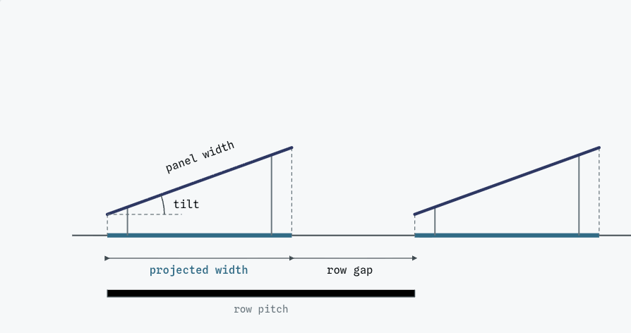
- Projected panel area
We first calculate the projected ground coverage area of the panels. Which tilt is used: For Fixed-tilt, East-west, we use the panel's configured surface tilt. For single-axis tracker, we use the Tracker angle normal use value you enter - Projected Ground Coverage Ratio
The projected panel area is then divided by the ground the rows sit on: the panel bands plus the gaps between them. This is the outlined block you see on the map.
